On May 18, 2011 I was interviewed by Rick Mitchell, chief meteorologist from Oklahoma City channel 5 (KOCO). It all started with the article on range oversampling that was featured on the May 2011 NSSL newsletter. The topic must have peeked their interest because the very quickly contacted our PR office to hear more about it.
Being my first time doing a TV interview, I was pretty nervous, but Rick did a wonderful job making me comfortable.
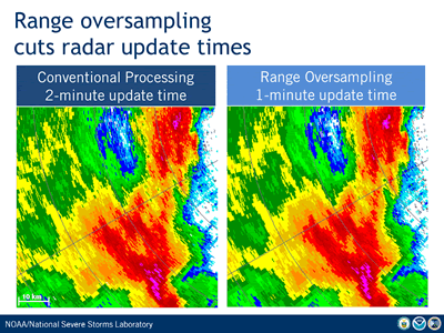
In a nutshell, range oversampling is a radar technique developed by scientists at the NOAA/National Severe Storms Lab that can be used to reduce radar update times and help National Weather Service forecasters get warnings out faster.
This technique solves the problem of getting faster updates while providing reliable weather data. Thanks to the great technological progress of the last decade, it is now possible to implement our most advanced engineering ideas, such as range oversampling, on operational radar systems. As the scientist who developed range oversampling over 13 years ago, this is like a dream come true!
If you didn't catch the interview on TV, here are the main points:
How does a Doppler weather radar work?
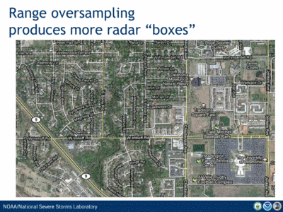
Doppler weather radars continuously monitor their surroundings by sending pulses of electromagnetic energy as they turn a full circle, similarly to a giant flashlight turning around. This energy bounces off water drops and is measured back at the radar. Weather data are collected for each location in 3-dimensional boxes, and that's how meteorologists can tell, for example, how much it's raining in your neighborhood. Typically, these radar boxes don't overlap (this is referred to as conventional sampling). So there is only one box above your neighborhood. The radar spends less than 1/10th of second sending a few tens of pulses and collecting data for that box; but it also collects data for thousands of other boxes, and does not come back to your neighborhood's box until it finishes covering the entire space around it. With our current technology, your neighborhood's box is examined about every 5 minutes.
Why do we need faster updates?
Imagine a tornado is approaching your neighborhood. In this case, NWS forecasters would want the radar to come back to your neighborhood's box much sooner than every 5 minutes to get more frequent updates of what's going on. It’s difficult to capture the evolution of such a dynamic event like a tornado if you take a picture of it every 5 minutes. You need faster updates. In other words, we'd like the radar to turn faster!
What is the problem with turning the radar faster?
There is a problem when turning the radar faster. If the radar turns faster, it won't have as much time to spend collecting data for your neighborhood's box, or in other words, it won’t have time to send as many pulses to this particular box. As a result of having less time, the measurements it obtains are not as reliable. In general, the quality of the measurement depends on the time the radar spends on it. This is similar to what happens at the doctor's office when a nurse takes your pulse. You may have noticed that the nurse needs to count your heartbeats for a few seconds before recording your pulse; listening to just a couple of heartbeats would not work as well! Another way to see this is that when the radar turns faster, it can’t send as many pulses to one box as before. The same effect occurs in an opinion poll. If you don’t talk to enough people, the poll results may not be reliable. Just the same, if a box doesn’t get enough radar pulses, the measurements are unreliable. The root of the problem is that not only do we want the radar to turn faster, but we also want the data it collects to be reliable, so that forecasters can have confidence in it to warn you with enough lead time of any severe weather approaching your neighborhood.
Finally, what is the solution?
Fortunately, we at the NOAA/National Severe Storms Lab found a way to make this work. With range oversampling, the radar turns faster but produces data for many more boxes than before, and these are overlapped. With this technique, there could be 4 or 5 boxes over your neighborhood. Now we can turn the radar faster, go back to that tornado about every 1 minute, and make up for the shorter time spent on each box by cleverly combining measurements from several overlapping boxes. In summary, range oversampling will allow forecasters to get warnings out faster, since the radar will turn faster while still taking reliable measurements of weather data.
We recently received a second award from the National Science Foundation (NSF) for our research project "Understanding the Relationship Between Tornadoes and Debris Through Observed and Simulated Radar Data."
This fall, I had the honor and privilege to teach an OLLI class with my friend and colleague Jami Boettcher. "NEXRAD Weather Radar: How it Works and What Those Images Tell Us" kept us busy for 5 weeks this fall.
Our paper "Bootstrap Dual-Polarimetric Spectral Density Estimator" made the cover of the April 2017 issue of the IEEE Transactions on Geoscience and Remote Sensing journal.
I have accepted to serve as an associate editor for the American Meteorological Society’s Journal of Atmospheric and Oceanic Technology.
I have been chosen as the winner of the 2016 OU College of Atmospheric and Geographic Sciences Dean’s Award for Outstanding Service.
![]() © 2020 Dr. Sebastian Torres. All rights reserved.
© 2020 Dr. Sebastian Torres. All rights reserved.
Last modified on 4/24/2020