 From the NWS Radar Operations Center website:
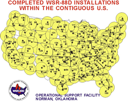
"NEXRAD is used to warn the people of the United States about dangerous weather and its location. Meteorologists can now warn the public to take shelter with more notice than any previous radar. There are 159 operational NEXRAD radar systems deployed throughout the United States and at selected overseas locations. The maximum range of the NEXRAD radar is 250 nautical miles. The NEXRAD network provides significant improvements in severe weather and flash flood warnings, air traffic safety, flow control for air traffic, resource protection at military bases, and management of water, agriculture, forest, and snow removal."
The following video provides a great introduction to the NEXRAD network:
We recently received a second award from the National Science Foundation (NSF) for our research project "Understanding the Relationship Between Tornadoes and Debris Through Observed and Simulated Radar Data."
This fall, I had the honor and privilege to teach an OLLI class with my friend and colleague Jami Boettcher. "NEXRAD Weather Radar: How it Works and What Those Images Tell Us" kept us busy for 5 weeks this fall.
Our paper "Bootstrap Dual-Polarimetric Spectral Density Estimator" made the cover of the April 2017 issue of the IEEE Transactions on Geoscience and Remote Sensing journal.
I have accepted to serve as an associate editor for the American Meteorological Society’s Journal of Atmospheric and Oceanic Technology.
I have been chosen as the winner of the 2016 OU College of Atmospheric and Geographic Sciences Dean’s Award for Outstanding Service.
![]() © 2020 Dr. Sebastian Torres. All rights reserved.
© 2020 Dr. Sebastian Torres. All rights reserved.
Last modified on 4/24/2020