|
ADAPTS active beam positions are determined based on two criteria: significance and neighborhood. |
Detecting regions with significant weather returns is the key for adaptive focused observations. ADAPTS works in real time by classifying individual beam positions within a scanning strategy as active or inactive based on two criteria: return significance and neighborhood.
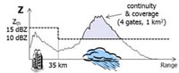
The first criterion activates beam positions if they contain significant weather returns. Beam positions with significant returns are those that contain range gates with reflectivity values above a range-dependent threshold (by default 15 dBZ within 35 km of the radar and 10 dBZ outside this range) that satisfy continuity and areal coverage requirements. Continuity requires a certain number of consecutive range gates (by default 4) with significant reflectivity values; coverage imposes a minimum total area (by default 1 squared km) of continuous significant reflectivity values.
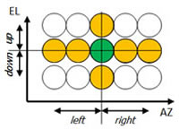
The second criterion activates neighboring beam positions to expand the coverage footprint to allow for continuous adaptation in response to storm advection and growth. Neighboring beam positions are defined by either a crosshair or rectangular mask with predefined azimuthal and elevation dimensions. By default, ADAPTS employs a crosshair mask of dimensions ±2.2° in azimuth and ±1° in elevation, but at least one beam position is added in each azimuthal and elevation direction, even if they fall outside the neighborhood mask. The typical spatial sampling of NWRT PAR scanning strategies leads to a maximum of 6 neighbors for each active beam position: one on either side in elevation, and two on either side in azimuth.
In ADAPTS, the classification of beam positions into active or inactive is used to redefine the scanning strategy that the radar will use next. This process repeats until a new scanning strategy is added to the task schedule or the pedestal is moved (e.g., to keep storms of interest in the antenna’s 90° azimuthal sector). Otherwise, the system can keep ADAPTS active-beam-position tables for up to 10 different scanning strategies in the task schedule.
In the initial implementation of ADAPTS, subsequent scanning strategies were redefined based only on active beam positions. That is, following an initial full scan (i.e., all active beam positions), only the active beam positions were scheduled to be scanned next, so data collection continued only on the set of active beam positions. In this scenario, subsequent determinations of active beam positions could only “dilate” or “erode” the previous set. Thus, to detect new developments in areas corresponding to inactive beam positions, a full scan (i.e., activating all beam positions) was required to be scheduled periodically (by default every 5 min). Because of this potentially longer time between observations in certain areas and the need to maintain continuous low-level coverage, an additional activation criterion was deemed necessary so that all beam positions below a given elevation angle (by default 2.5°) were always active.
Whereas the initial implementation of ADAPTS (herein referred to as ADAPTS I) showed significant performance improvements compared to conventional scanning strategies, especially when observing isolated storms, timely detection of new developments was not guaranteed because inactive beam positions were only scanned once every 5-10 min.
The new implementation of ADAPTS (ADAPTS II) was designed to mitigate the limitations of ADAPTS I in terms of timely detection of new developments. With ADAPTS II, subsequent scanning strategies are redefined as follows. Whereas active beam positions are scanned with full spatial resolution and full dwell times (as with ADAPTS I), areas of inactive beam positions are also scanned but with coarser spatial resolution (i.e., with azimuthal sampling equal to the beamwidth, instead of half the beamwidth as normally done for active beam positions) and shorter dwell times (i.e., fewer pulses, by default 4). Scanning inactive areas in this manner makes sense because data from inactive beam positions are not meant to be disseminated to users or algorithms; they are only needed to detect new storm developments. As a result, even when continuously scanning both active and inactive beam positions, reduced update times are possible because the latter only takes a fraction of the typical acquisition time. In this manner, ADAPTS II results in an effective compromise that produces good-quality data with faster updates on smaller areas of interest while, at the same time, performing continuous surveillance to capture new storm developments in a timely manner.
Time-series data acquired at inactive beam positions with ADAPTS II are processed using a newly developed surveillance processing mode, which differs significantly from the processing mode used to generate meteorological-variable estimates for users and algorithms. The surveillance mode operates on very few samples (by default 4) per dwell and needs to determine the presence of significant returns in a robust manner. That is, a compromise must be achieved between the probability of detecting significance and the occurrence of false detections. The former is required to achieve timely detection of newly developed weather phenomena and the latter is needed to prevent adding beam positions with no significant weather returns to the set of active beam positions.
Processing in the surveillance mode exploits range averaging to reduce the variance of reflectivity estimates so that significance can be more robustly determined. Due to the small number of samples, ground clutter mitigation is very difficult. Therefore, the surveillance mode relies on a spatial database of ground clutter powers. These are subtracted from total power estimates at each range gate to produce an approximate weather-signal power from which significance is determined. The database of removed ground clutter powers is completely populated when the first (full) scan runs and is continuously updated with data from the active areas. The amount of power removed by the CLEAN-AP ground clutter filter is used as a proxy for ground clutter power.
Because significance determination is not robust when processing a small number of samples, a persistence criterion must be met before a beam position with significant returns (as determined by the surveillance mode) becomes active. That is, beams from inactive areas with significant returns are temporarily activated without using the neighborhood criterion. As such, a false detection only results in the addition of one beam to the set of active beam positions and minimizes the visual impact of false detections on the meteorological data. The neighborhood criterion is applied as usual once significance is confirmed using full dwell times.
We recently received a second award from the National Science Foundation (NSF) for our research project "Understanding the Relationship Between Tornadoes and Debris Through Observed and Simulated Radar Data."
This fall, I had the honor and privilege to teach an OLLI class with my friend and colleague Jami Boettcher. "NEXRAD Weather Radar: How it Works and What Those Images Tell Us" kept us busy for 5 weeks this fall.
Our paper "Bootstrap Dual-Polarimetric Spectral Density Estimator" made the cover of the April 2017 issue of the IEEE Transactions on Geoscience and Remote Sensing journal.
I have accepted to serve as an associate editor for the American Meteorological Society’s Journal of Atmospheric and Oceanic Technology.
I have been chosen as the winner of the 2016 OU College of Atmospheric and Geographic Sciences Dean’s Award for Outstanding Service.
![]() © 2020 Dr. Sebastian Torres. All rights reserved.
© 2020 Dr. Sebastian Torres. All rights reserved.
Last modified on 4/24/2020